In 1996, MBTA Promised Green Line to Somerville by 2011
Posted on August 2nd, 2011 at 7:21 pm by Steve


In 1996, the MBTA planned to have the Green Line extended to Somerville by 2011.

Today, in 2011, the Patrick administration announced that they will be delaying – until at least 2018 – construction and operation of the Green Line into Somerville and Medford.

Long-time watchers of Somerville’s transit woes (such as this author) are unsurprised by this latest development.

Courtesy of those pesky “archives” that libraries seem to love, here’s a Boston Globe article from January 28, 1996 (more than FIFTEEN years ago!):

Slater, the T’s planning director, contends, “Somerville probably has more bus service than any comparable area. It’s got a lot of service going into both Lechmere and Sullivan, where people can make connections. Part of the long range plan is to extend the Green Line into Somerville. The deadline on that is the year 2011, and we’re trying to meet earlier deadlines now on other projects.”

I guess the good news is that the planning horizon today is half what it was in 1996. Maybe in 2018, they’ll announce service in 2022. And, in 2022, they’ll announce service in 2024. And, in 2024, they’ll announce service in 2025, and maybe by then it will actually be built.

I’m not holding my breath.

Nuke New England!
Posted on April 18th, 2011 at 3:03 pm by Steve


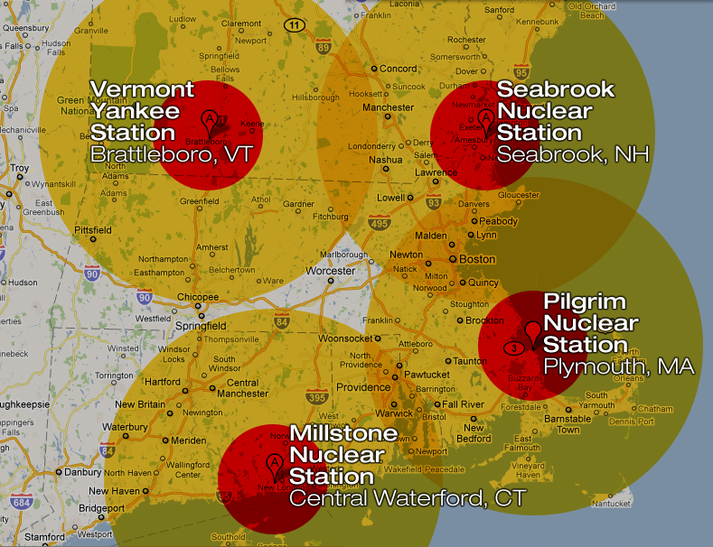
Imagine a “station blackout” occurs at the Pilgrim Nuclear Generation Station in Plymouth, MA. Within days, a hydrogen explosion shatters the secondary containment building, possibly breaching primary containment as well. The government orders a mandatory evacuation for areas within 20 km of the plant, but the BBC World Service is saying that the British government has advised their citizens not to travel within 50 miles of Plymouth.

This catastrophe at Plymouth (or Seabrook, or Vermont Yankee, or Millstone in Connecticut) hasn’t happened…yet. But the notion that “it can’t happen here” has taken quite a beating over the last month. If and when a disaster like this strikes, we’ll have hours to evacuate. Think for a moment what it would take to evacuate just the inner “exclusion zone” around one of these reactors. Where are we going to put all the people from Brockton, Plymouth, Taunton, Fall River, Buzzards Bay, Sandwich…? And what about the more than a million people that live within 50 miles? Remember that, even now, the US government is advising Americans not to travel within 50 miles of Fukushima, a month after the crisis began. How can we avoid travel to the entire Boston metro area?

Of course, Pilgrim only has one reactor, where Fukushima Daiichi has six. On the other hand, Pilgrim has more than TWO MILLION POUNDS of radioactive spent fuel assemblies stored on site. A loss of coolant water in the tightly-packed spent fuel pool at Plymouth – which has far less containment, and far more fuel, than the reactor core – could quickly lead to a fire and a massive excursion of radioactive isotopes of cesium, strontium, iodine, and others. An explosion could spread deadly plutonium and uranium particles for miles (as happened at Fukushima). In other words, even with fewer reactors, a station blackout at Plymouth could have worse radiological consequences than the ongoing disaster in Japan.


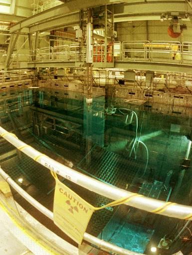
The spent fuel pool at Vermont Yankee

The reactor at Plymouth is a General Electric Mark I Boiling Water Reactor, the same design and vintage of the “troubled” reactors in Japan. Of course, America’s Nuclear Industry and Regulators (is there a difference?) are quick to point out that American reactors have strict safety standards and have been upgraded and so on. Ask them about the spent fuel pools. Ask them how long they can run the pumps to maintain sufficient cooling in the event of a station blackout (whatever the cause). Ask them the consequences of allowing the operator to store 2,918 spent fuel assemblies in a pool that was designed and originally licensed to hold just 880 assemblies.

Of course, the spokesman for Vermont Yankee is quick to assure us, “We believe pools are perfectly safe. It was designed to be safe and there are redundant systems so there is never a loss of coolant.” Indeed. For some reason, those fools in Japan neglected to design their pools to be safe, and that’s why they suffered a complete loss of coolant and melting of the fuel rods in the spent fuel pool. Silly Japanese!

Ghosts of Discount Retail Past
Posted on April 14th, 2011 at 11:35 am by Steve

Spotted on Somerville Avenue next to McGrath Highway… once the haunt of Mrs. B and a long-departed Stop & Shop; later the home of electronics retailer Fretter; and, most recently, host to the lowest rung of the TJX retail hierarchy, the now-defunct A.J. Wright.

Who Watches the (Weather) Watchmen?
Posted on April 13th, 2011 at 5:51 pm by Steve


I’ve long wanted to keep records of weather forecasts and compare them to actual results. But, I’m too lazy.

Fortunately, Forecast Advisor has started to do that for us! And, it turns out that my suspicions were correct.

At least for Boston, the weather forecasts are less than 80% accurate. Now, consider that these data are looking at just the 1-3 days ahead forecasts, and in fact are collapsing the data. The day-ahead forecasts are usually more accurate than the 3-days ahead forecasts. The company sells a data feed that I’m sure drills down to this level and beyond.

But consider: for March 2011, the National Weather Service predicted the high temperature within 3° F of the actual high temperature only 40% of the time! They accurately predicted the low temperature +/- 3° 53% of the time in March. They did slightly better with their precipitation forecasts – if they called for rain or snow, they were right about 83% of the time.

Over the past year, they did better on temperature predictions (63% right on the highs, 70% right on the lows) but worse on the precipitation calls (75% accurate).

What can we conclude? National Weather Service forecasts are better than chance… but not by a lot. Turns out, you don’t need a Weatherman to know which way the wind blows…

Let’s Roll!
Posted on April 25th, 2010 at 11:51 am by Steve

Candelpin bowling is making a comeback! The Boston Globe Magazine is on the story this Sunday, featuring a local star bowler named Jeff Surette:

he just wants to bowl, just wants to take what he can get from the most difficult form of bowling on the planet, a particularly New England pursuit that is as hard as a Maine winter.

Classic!

Regular readers of the blog (hi Mutt!) will recall that we mentioned the story of another local bowler back in December, when his record-breaking three-string score of 514 was kept out of the record books because the foul line sensor was not turned on.

Somerville Breakfast Wars Draw Blood
Posted on April 13th, 2010 at 5:29 pm by Steve

If you’re local to Somerville (like some of us are, or were), then you’ve hopefully enjoyed a fantastic breakfast at either or both of Sound Bites and the Ball Square Café. There’s been bad blood between the two ever since Sound Bites expanded to the building next door, and the owners of the old space rented it to their son, who convinced the old Sound Bites chef to stay behind. The Somerville News’s blog picks up the story:

Police were called to Broadway today as a crowd scuffled and tried to separate the owners of SoundBites and Ball Square Cafe. It wasn’t the first time police were called to mediate Ball Square owner Mike Moccia and Yasser Mirza, of Sound Bites, but it may have been the most intense episode yet with witnesses reporting punches thrown and blood drawn.

Water, Water Everywhere…
Posted on March 29th, 2010 at 1:57 pm by Steve

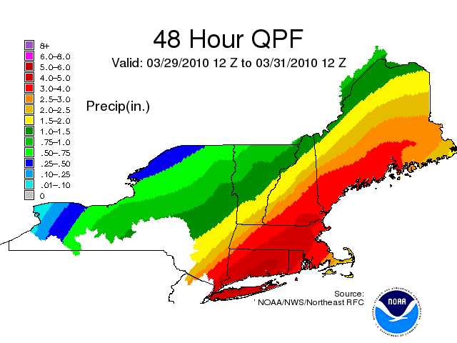
The image above is the National Weather Service’s Quantitative Precipitation Forecast for the next 48 hours. It predicts 4-5 inches of rain for the Boston metro area between now and midday Wednesday!

Tim Anderson Bubbles Up in the New York Times!
Posted on March 26th, 2010 at 5:17 pm by Steve

Friend of the blog Tim Anderson bubbles up in a New York Times article about Kombucha (a drink many NII bloggers were enjoying back in the mid-90’s thanks to Shwilly B!):

Kombucha’s popularity has also attracted home brewers. Tim Anderson, founder of a 3D printer technology company, moved from Boston to Berkeley, Calif., with his “mother” — passed on to him from a friend who got it, as the story goes, from gypsies in Russia.

Mr. Anderson, an advocate for all things do-it-yourself, made step-by-step kombucha brewing instructions complete with videos for Instructables.com (one of over 200 tutorials he has made on everything from tire sandals to wheelchair shopping carts). Nearly 60,000 people have viewed the kombucha guide to-date, according to the site’s page-view statistics.

“I’m surprised people would pay to get this stuff,” Mr. Anderson said. “The kind you can buy tastes vinegary and dry, whereas the one you can make yourself is so incredibly delicious.”

Mr. Anderson has given kombucha culture to dozens of friends and strangers. Recently he put out a call to get some back after he neglected his brew and let the fermented patty dry out. “You can’t go around saying you killed your mother,” he said. “It freaks people out.”

Public Utility Chutzpah
Posted on February 22nd, 2010 at 6:35 pm by Mutt

PG&E Building in San Francisco

Today, I noticed an ad for California Prop 16, with the catchline “Preserve Your Right To Vote.” Thinking that this sounded like a lot of spin, I decided to look it up.

According to Ballotpedia, this is basically an initiative funded by PG&E to make it more difficult for municipalities to start their own utilities.  It would amend the California state constitution to require that any Community Choice Aggregator be approved by a 2/3 vote.

Now, I already thought that California’s system for amending the constitution by a simple majority is ridiculous, but this really takes the cake.  (Perhaps even the lemon olive oil cake.  See below.)

Let me get this straight — you’re using a simple 50% vote to require that, in the future, individual communities need a 2/3 majority to do something?  That seems really backward.

But what really gets me is that PG&E, a monopoly public utility, is planning on spending $25-35 million dollars to singlehandedly fund the campaign for this initiative — that’s money that we’re paying them!

Best…Area Forecast Discussion…EVER!
Posted on February 21st, 2010 at 11:54 pm by Steve

If you’re like me – and I know I am – you love trying to understand and predict the weather. On the off chance you’re not like me, I’m reposting below my favorite recent “Area Forecast Discussion” product from the National Weather Service’s Taunton, MA office. Even with the jargon and peculiar typographic conventions, you can get a pretty keen sense of how weather systems and forecasts work by reading this discussion:

838
FXUS61 KBOX 220357
AFDBOX

AREA FORECAST DISCUSSION
NATIONAL WEATHER SERVICE TAUNTON MA
1057 PM EST SUN FEB 21 2010

.SYNOPSIS…
TWO LOW PRESSURE SYSTEMS ARE FORECAST TO DEVELOP OFF THE MID ATLANTIC COAST THIS WEEK AND COULD BRING PERIODS OF WINTRY WEATHER…MAINLY TO THE INTERIOR. THE FIRST SYSTEM IS LIKELY TO AFFECT THE REGION TUESDAY AND WEDNESDAY AS IT TRACKS ACROSS SOUTHERN NEW ENGLAND. A SECOND COASTAL STORM MAY AFFECT THE AREA LATE THURSDAY INTO FRIDAY AS IT TAKES A SIMILAR TRACK THROUGH OUR AREA.

&&

.NEAR TERM /UNTIL 6 AM MONDAY MORNING/… FOR THE OVERNIGHT FORECAST…HAVE LOWERED SKY COVER GRIDS TO ALMOST CLEAR OVER MOST OF THE AREA. SOME CIRRUS ADVANCING THROUGH EASTERN NY…SOME LOW CLOUDS IN THE HIGHER ELEVATIONS OF CHESHIRE COUNTY ARE THE TWO EXCEPTIONS. SATELLITE IMAGERY SHOWS HIGH CLOUDINESS SPILLING SOUTHWESTWARD OVER THE GULF OF MAINE AS ANOTHER SPOKE OF VORTICITY ROTATES AROUND THE UPPER LOW. 00Z NAM BRINGS THE CLOUD COVER INTO MASS BAY BY DAYBREAK THEN BACK EASTWARD OUT TO SEA…SO ADDED THIS TO SKY COVER GRIDS. NO CHANGES TO TEMPERATURE FORECAST OVERNIGHT. LOWERED WIND GUSTS IN WESTERN MA BUT KEPT WINDS AS FORECAST ALONG THE COAST OVERNIGHT SINCE BOS STILL GUSTING TO 24 KTS AS OF 10 PM.

&&

.SHORT TERM /6 AM MONDAY MORNING THROUGH MONDAY NIGHT/…
MONDAY…THE FORECAST AREA WILL RESIDE WITHIN A COL AREA BETWEEN HIGH AND LOW PRESSURE SYSTEMS. ANTICYCLONIC FLOW ALOFT WILL ALLOW FOR SUBSIDENCE AND MOSTLY CLEAR SKIES. WILL NOTE SOME INCREASING HIGH CLOUDS LATE IN THE DAY WELL AHEAD OF ADVANCING LOW PRESSURE ACROSS THE GREAT LAKES.

TEMPERATURES ARE EXPECTED TO REBOUND TO ABOVE SEASONAL NORMS…IN THE 40S MOST LOCATIONS. DEVELOPING LIGHT ONSHORE FLOW WILL ALLOW FOR COOLING TEMPERATURES ALONG THE COAST DURING THE AFTERNOON. STAYED FAIRLY CLOSE TO THE MILDER MAV MOS GUIDANCE MOST AREAS.

MONDAY NIGHT…THE WEAK H5 RIDGE WILL BE MOVING EAST OF THE AREA. NOTED AN APPROACHING H7 MID LEVEL JET PROVIDING INCREASING MID LEVEL CONVERGENCE ACROSS THE SOUTHWESTERN ZONES APPROACHING DAYBREAK FROM THE LATEST OPERATIONAL NAM/GFS. A LOW LEVEL ESE JET AHEAD OF DEVELOPING LOW PRESSURE OFF THE NORTH CAROLINA COAST WILL PROVIDE SOME INCREASING LOW LEVEL CONVERGENCE AND ATLANTIC MOISTURE AFTER 06Z ACROSS THE SOUTHWEST ZONES. THE MAIN FOCUS FOR DEEP LIFT WILL LIKELY OCCUR WELL AFTER 06Z.

THERE ARE TIMING ISSUES REGARDING THE ARRIVAL TIME OF PRECIPITATION BUT FEEL IT WILL TAKE SOME TIME FOR THE LOWER LEVELS FROM H85 TO THE SURFACE TO MOISTEN. THUS HAVE CHANCE POPS ADVERTISED FROM 06Z THROUGH 12Z ACROSS THE WESTERN ZONES…BUT REMAINING DRY UNTIL AFTER DAYBREAK ACROSS THE EAST. TEMPERATURE PROFILES REMAIN COLD ENOUGH TO SUPPORT MOSTLY SNOW THROUGH DAYBREAK.

&&

.LONG TERM /TUESDAY THROUGH SUNDAY/…
VERY COMPLEX WX PATTERN DURING THIS EXTENDED PERIOD WITH PERSISTENT NORTH ATLANTIC BLOCKING REMAINING IN PLACE. SIGNIFICANT TROF AMPLIFICATION OCCURS OVER MIDWEST AND OHIO VALLEY EARLY IN THE PERIOD AS PIECE OF ENERGY BREAKS OFF FROM HUDSON BAY VORTEX AND FORMS ANOTHER CLOSED VORTEX WHICH DROPS SWD ACROSS OHIO VALLEY EVENTUALLY SHIFTING EAST OVER NEW ENG TOWARD THE END OF THE WEEK. POTENTIAL FOR 2 STORMS TO AFFECT SNE DURING THE PERIOD.

HIGH CONFIDENCE IN A PROLONGED WINTER WEATHER EVENT ACROSS SNE THROUGH AT LEAST WED ALTHOUGH THERE REMAINS CONSIDERABLE UNCERTAINTY IN DETAILS OF QPF AND PTYPE. GREATEST PROABILITY FOR SIGNIFICANT SNOW ACCUM DURING TUE-WED PERIOD WILL MOST LIKELY BE OVER NW HIGH TERRAIN.

COASTAL STORM DEVELOPS OFF MID ATLC COAST TUE AS PIECE OF SHORTWAVE ENERGY BREAKS OFF FROM DEVELOPING VORTEX DROPPING SOUTH INTO THE MIDWEST. THERE IS CONSIDERABLE MODEL SPREAD WITH THE TRACK OF THIS STORM SO CONFIDENCE IN THE DETAILS OF QPF/PTYPE IS LOW. GFS/NAM FURTHEST EAST AS THEY DEVELOP THE STORM WELL OFFSHORE ALTHOUGH INVERTED TROF HANGING BACK TO THE WEST ENSURES PRECIP ACROSS SNE. OP GFS HAS NO SUPPORT FROM MAJORITY OF ITS ENSEMBLE MEMBERS WHICH ARE FURTHER WEST BUT ALSO CONDISERABLE SPREAD AMONG ALL MEMBERS. GGEM ON WESTERN ENVELOPE OF SOLUTIONS TRACKING STORM NWD THROUGH NYS. ANSWER PROBABLY LIES SOMEWHERE IN BETWEEN MORE IN LINE WITH ECMWF/GEFS MEAN/SREF BLEND WHICH TRACK STORM SLOWLY NWD INTO E NEW ENG DURING WED.

CURRENT THINKING IS PRECIP WILL OVERSPREAD THE REGION FROM WEST TO EAST DURING TUE…BUT HEAVIER QPF WILL PROBABLY BE FOCUSED ACROSS LOWER CT VALLEY TUE WITH STEADIER PRECIP MOVING EAST ACROSS REST OF SNE TUE NIGHT.

PTYPE IS TRICKY. PRECIP COULD BEGIN AS A PERIOD OF SNOW IN THE COASTAL PLAIN BUT WE THINK THERE IS TOO MUCH LOW LEVEL ELY FLOW WHICH SHOULD OVERWHELM THE BOUNDARY LAYER RESULTING IN MOSTLY RAIN FROM BOS-PVD SEWD WITH SOME MIXING POSSIBLE TUE NIGHT. NOT BUYING THE COLD NAM SOLUTION FOR BOS/PVD AS MAIN STORM IS LIKELY TOO FAR EAST. BEST CHANCE FOR ALL SNOW WILL BE OVER ELEVATED TERRAIN IN BERKSHIRES…MONADNOCKS AND HILLS ACROSS NORTHERN ORH COUNTY. IN BETWEEN THESE 2 AREAS FROM N CT AND MASS PIKE REGION NORTHWARD ALONG I495 BELT IS WHERE CONFIDENCE IS LOWEST IN PTYPE. WILL PROBABLY SEE A PERIOD OF SNOW THEN MIXED RAIN/SNOW AS BOUNDARY LAYER WARMS.

PRECIP CONTINUES INTO WED…BUT SHOULD BEGIN TO TAPER OFF FROM SOUTH TO NORTH DURING AFTERNOON/EVENING AS DRY SLOT MOVES IN WITH APPROACH OF SFC LOW. HIGHEST PROBABILITY FOR GREATER THAN 6″ WITH LOCALLY UP TO A FOOT WILL BE OVER NW HIGHER TERRAIN…WITH ADVSY SNOWFALL POSSIBLE IN INTERIOR NW OF I95. FOR THE COASTAL PLAIN…THINKING RIGHT NOW IS LITTLE ACCUM EXPECTED.

THEN THERE IS THE SECOND COASTAL STORM WHICH DEVELOPS IN RESPONSE TO VORTEX MOVING EWD FROM OHIO VALLEY AND OFF THE MID ATLC COAST THU INTO FRI. AGAIN THERE IS CONSIDERABLE UNCERTAINTY ON THE EVOLUTION OF THIS STORM AS THE INTERACTION OF SEVERAL SHORTWAVES WILL ULTIMATELY DETERMINE THE POSITION OF THE VORTEX AND EVENTUAL DEVELOPMENT/TRACK OF COASTAL STORM. STILL WAY TOO EARLY TO EVEN ATTEMPT TO PIN ANYTHING DOWN SO WE JUST HAVE CHC POPS FOR NOW.

UNSETTLED WEATHER COULD LINGER INTO SAT WITH SOME IMPROVEMENT POSSIBLE BY NEXT SUNDAY.

&&

.AVIATION /04Z MONDAY THROUGH FRIDAY/…
OVERNIGHT…HIGH CONFIDENCE VFR.

MONDAY…HIGH CONFIDENCE VFR.

MONDAY NIGHT…VFR CEILINGS EXCEPT LOW TO MODERATE CONFIDENCE MVFR/IFR CEILINGS AND VSBYS IN DEVELOPING -SN KBAF-KBDL-WST BY 09Z.

OUTLOOK…TUESDAY THROUGH FRIDAY…

TUE-WED…HIGH CONFIDENCE OF MVFR CIGS/VSBYS IN MIXED RAIN/SNOW WITH PERIODS OF IFR POSSIBLE. GUSTY EASTERLY WINDS ALONG THE COAST.

THU-FRI…CONDITIONS DEPEND ON DEVELOPMENT/TRACK OF SECOND COASTAL STORM. THERE COULD BE MORE MVFR/IFR CONDITIONS AND GUSTY WINDS BUT CONFIDENCE IS VERY LOW.

&&

.MARINE…
OVERNIGHT…SMALL CRAFT ADVISORIES REMAIN IN EFFECT FOR THE OFFSHORE WATERS AS OF 10 PM…STILL HAD GUSTS TO 29 KTS AT BUOY 44018 AND TO 27 KTS AT 44013. ALSO SEAS WILL AVERAGE 4 TO 6 FEET OVERNIGHT.

MONDAY…A SMALL CRAFT ADVISORY WILL MAY NEED TO BE EXTENDED UNTIL AROUND NOON FOR LEFTOVER HAZARDOUS SEAS ACROSS THE OUTER COASTAL WATERS.

MONDAY NIGHT…A SMALL CRAFT ADVISORY MAY BE NECESSARY APPROACHING DAYBREAK TUESDAY ACROSS THE SOUTHWESTERN WATERS AS LOW PRESSURE DEVELOPS OFF THE NORTH CAROLINA COAST.

OUTLOOK…TUESDAY THROUGH FRIDAY…

TUE-WED…INCREASING E-NE WINDS WITH PROLONGED PERIOD OF GUSTS TO 30 KT EXPECTED. LOWER PROB OF GALE FORCE GUSTS DEPENDING ON TRACK/DEVLOPMENT OF THE FIRST COASTAL STORM. ECMWF WOULD BRING STRONG GALES TUE NIGHT INTO WED FOR EASTERN WATERS BUT GFS IS WEAKER. SEAS LIKELY BUILDING TO OVER 10 FEET OVER OUTER WATERS BY WED…POTENTIALLY STRONGER IF ECMWF SOLUTION VERIFIES.

THU-FRI…WINDS/SEAS WILL DEPEND ON DEVELOPMENT/TRACK OF POSSIBLE SECOND COASTAL STORM. THERE IS CONSIDERABLE MODEL SPREAD WHICH RESULTS IN VERY LOW CONFIDENCE ON WIND SPEED AND DIRECTION.

&&

.TIDES/COASTAL FLOODING…
COASTAL FLOOD TREAT IS LOW THROUGH TUE DUE TO LOW ASTRO TIDES AND SEAS NOT HAVING BUILT UP ENOUGH BY THEN. COASTAL FLOOD POTENTIAL INCREASES FOR THE WED MORNING HIGH TIDE. STORM SURGE OF 2 FEET COMBINED WITH 10-15 FT SEAS OFFSHORE COULD YIELD WORST CASE SCENARIO OF MINOR FLOODING.

HOWEVER…BEACH EROSION MAY BECOME A PROBLEM ON EAST FACING BEACHES DUE TO PERSISTENT EASTERLY FLOW OVER MULTIPLE HIGH TIDE CYCLES.

NEXT STORM AFFECTING REGION TOWARD END OF WEEK ALSO BEARS WATCHING AS ASTRO TIDES ARE HIGHER.

&&

.BOX WATCHES/WARNINGS/ADVISORIES…
CT…NONE.
MA…NONE.
NH…NONE.
RI…NONE.
MARINE…SMALL CRAFT ADVISORY UNTIL 6 AM EST MONDAY FOR ANZ250-254>256.

&&

$$
SYNOPSIS…KJC/STRAUSS/GAF
NEAR TERM…GAF
SHORT TERM…STRAUSS
LONG TERM…KJC
AVIATION…KJC/STRAUSS
MARINE…KJC/STRAUSS
TIDES/COASTAL FLOODING…KJC

« Previous Entries